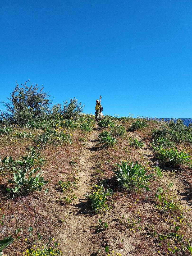
Above: Initial rise above parking area. We’re the first ones to arrive but soon vehicles packed with paraglider gear will fill up this small pullout by the road. Spring flowers underfoot, distant view of the Enchantments (popular backcountry & Alpine Lake hiking area) Above: Starting while it’s still barely 40 degrees, ultimately the total gain will be 1100 ft. vertical. Above: Note the tiny white spot sandwiched between the rolling valley hillsis actually an artist’s retreat that has a private snaking driveway starting up from the valley road. Above: A panoramic town view of Cashmere with the Enchantment Range mountains in the western distance. This year’s late winter snowstorms seem to be delaying the start of summer hiking/climbing season in much of the higher Cascades.Above: Okay folks, this is the way to the top. The road trail ended here at an old communication tower on a flat area at the top of a cliff. About ten paragliders were hiking up with their bulky packs. They will gear up here and jump off the cliff, planning to ‘catch the thermals’ that will keep them in the aloft. Their goal was to float to Chelan, nearly 40 miles away. Meanwhile, we will climb up the last half-mile to the ‘true’ top.Above: Made it to the top. When there is nothing but bluest skies around, you know it’s the peak.Above: These Balsamroot beauties appear to be looking at you, but actually these phototropic flowers continually turn to face the sun. Above: This last section of steep trail downhill completes the loop. Other hikers’ reviews warned that it is too steep, too hard on the old knees. But it’s on the map, why not? Will take a day off tomorrow; No wildlife today, but a ‘birder’ told us about a woodpecker indigenous to this area, one with a bright orange belly, unique in that it doesn’t ‘peck’, but catches bugs while flying.
NOTE: Being warned that Pacific Northwest weather has a week stretch of ‘liquid sunshine’ in store -starting tonight- it’s smart to hustle back to the car. UPDATE on my new book: MEET ME IN BISBEE…It’s ready, it’s screaming to get self-published into paperback form…but life delays happen. ETA to appear on Amazon remains late Summer.CheeriosAll!
First a little geology back up info: Many millions of years, tectonic upheavals and eruptions resulted in volcanos with solid magma rock cores. The softer materials eroded away leaving the spires we see today, like these two on Saddle Rock. The Ice Age floods inundated this entire region, adding rich soil. In the vibrant town of Wenatchee, life is all about apple orchards. In 2023 140mil. cartons (40-pound boxes) of apples produced and over 18 million cartons were shipped to countries like Mexico, Taiwan and Canada.
Above: On this brilliant sunny day, the loop hike of 4miles, starting temps stayed only at 40degrees, once the elevation started to grind up warmed up to high 50’s. Saddle Rock is the inside rocky remains of an ancient volcano.Below: Hundreds of snaking trails covered this area, some traversing the canyon, some very narrow and steep but ultimately joining the main trail. Below: Our tour leader reached a spire top and as always, he is on the lookout for new spur trails. Below: Mocha at the ridge tracking scents. Way down below are the trails leading to this saddle.Below: Native American tribal artists used spiral figures to reflect on cyclical life circles and spiritual growth. This rock design obviously has been created by a hiker of modern times at the elevation of 2200 ft- high elevation. Frequent local hikers said it has been there for several years. Question is: Every 30-40 pound rock is a smooth river rock and had to have been carried here. Who on earth did that??Below: View of the Columbia River winding its way south before it turns westward and becomes the border between Washington and Oregon States. The two pieces of Saddle Rock below are the remaining edges of the ancient volcano. ABOVE: OMG! Some hiker really built a swing up here ? Below: Welcome to my personal garden of healthy vibrant Balsamorhiza {Balsam Root Flowers} and deep blue lupines. Brought home a whole bouquet of each.Below: As high as we go today, time to head cross-country and start our descent. Below: We descended a ravine laced with trails, so many to choose from! Thank goodness one we took did actually connect with the main trail back to the car. Sometimes an unknown path you take, may end up diverting you to the other side of the mountain. Below: A few sprinkles caught up with us courtesy of this ominous cloud. Never enough time to immerse fully into this magical maze of hundreds of little patinas. Overall, a wonderful day and a picturesque hike.
NOTE: Stay tuned for tomorrow’s planned next loop-hike also nearby. Town with a pretty name, Cashmere. Also, a loop of 4 miles that will climb up to a peak and will descend on a very steep narrow trail. But first enjoy fine dining @Mc D’s and overnight until 5.30am before starting the new adventure. HAPPY TRAILS.
Below: The racer yacht PALONG BAY representing Vietnam was the first one to arrive in Seattle which makes her the candidate with more chances to win the full circuit. One of the crew members reported that the reason of their early arrival was because they opted to take the Southern route instead of Northern and sailed with a crew of 14 rather than 21. Lighter, thus were faster.Below: Leave it to Mocha to inspect the welcoming tent and gather a lot of tummy rubs from the ocean sailors. The vessels are open for touring or signing up for full or part crewing.Anyone up for this?Above: Getting all the inside scoop from the Dutch crew gents from PERSEVERANCE. Their journey took 28 days from China averaging 7 knots per hour. They are staying at a nearby hotel instead the yacht. Navigating work was 24/7, they are fed measured nutrition-focused meals and allowed seconds.
We learned that it was March of year 2023, a panel announced the 11 Skippers from all walks of life and countries to be the skippers of eleven yachts.Since thenthey have been training for this ultimate journey hoping to be the winner. We also learned that the race has a website, that family/friends fly to each stop to visit or monitor their progress via the website. Seattle is the end of Leg 6. Next is Leg 7 Seattle via Panama Canal to Washington DC, then final Leg 8 to England. All should follow to see the skipper of the WINNER.
NOTE: This whole week is nothing but rain/or snow around the PNW mountain peaks, depending on the altitude you plan for, so this ultimate test for ocean buffs provided the missing element of adrenalin for grounded hikers. One has to learn how to wait for the right conditions. Besides, my new Book is still next in line waiting for editing. Title will be: MEET ME IN BISBEE! Happy Spring Showers!
First a little info: Eastern Washington near town Quincy. A Classroom for Geology buffs. This whole basin is called Columbia River Plateau that goes back to 40/60 mil.years of origin. But later, around 10/18 mil. years ago, volcanic eruptions and lava flows formed the earth crust. ‘Coulees’ [flows in French] carved perfectly shaped basalt columns and canyons.
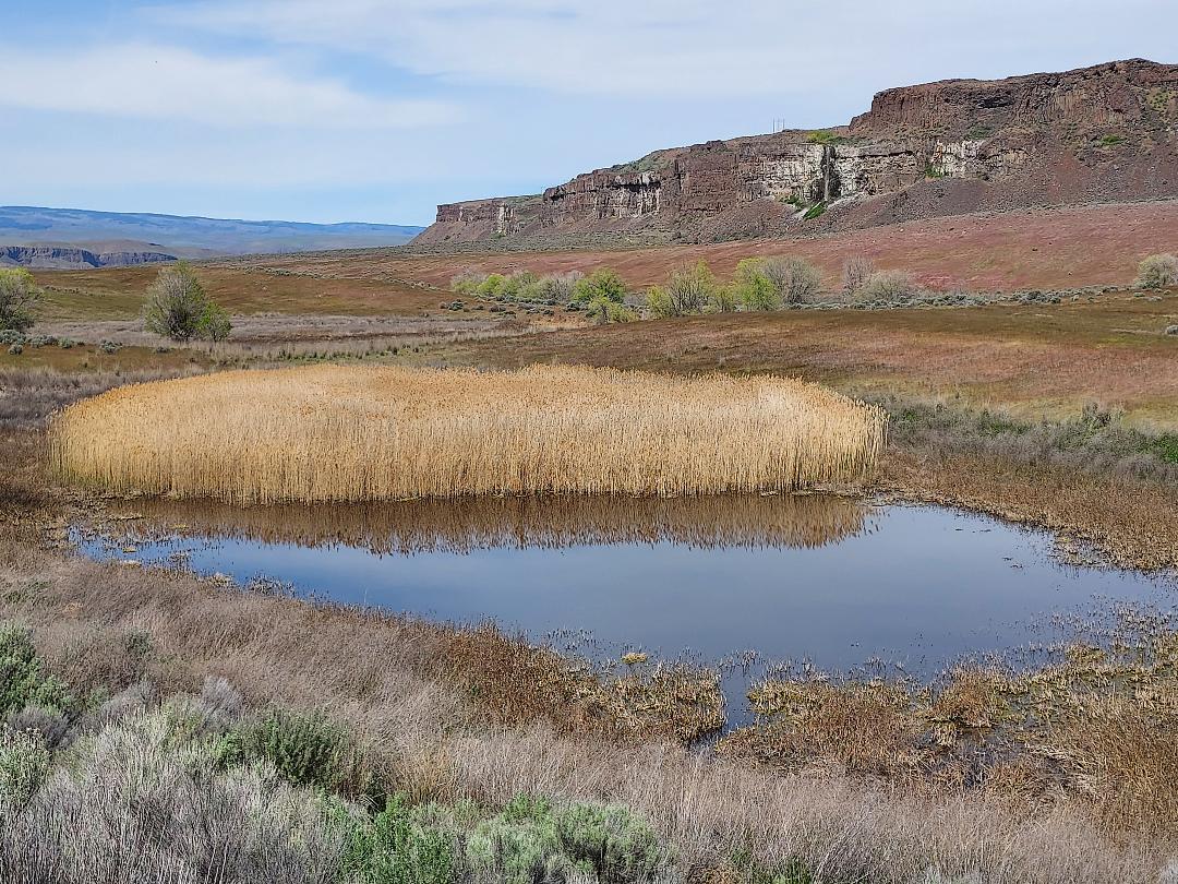
Above: The start is mostly on fine dirt surface with a moderate climb followed by descending down the canyon. There will be no rapid altitude in this loop trail….EXCEPT the last part when there is nothing but a talus scramble next to the waterfall to get back up. Pix at the end will tell all! Above: First is the Dusty Lake. Today there were more hikers than expected. Mostly folks with fishing gear, campers and horse-back riders, because it’s near a horse camp. Above: Perhaps hundreds of different trails and no signs. So easy to get lost here, and we certainly did. Above: An island like outcrop of basalt columns.Above: Besides the Ancient Lakes, there is also a lot of ponds and waterfalls. This one has reeds at the centre. Above: A surprise for Mocha! Across the water, views of basalt heights, couple of horses and their riders having a shade break.Above: We’re now return section of the loop. Since the next 4/5 day to be rainy we’re keeping an eye on the change of weather.Above: A perfect shady spot for lunch. Notice backpacks are kept off the ground? Because ticks are out, and some actually turned up in between our cloths. Above: This is the real Ancient Lake and its Waterfall. All was well until this point, when the thin path next to the water edge ended. And the sliding rocky path by the waterfall is the only way up to complete the loop!Above: Another hiker with a dog kind of led the way and begrudgingly so did we.
NOTE:THANKS FOR SHARING, ALL. Keep your comments coming. HASTA LA VISTA.
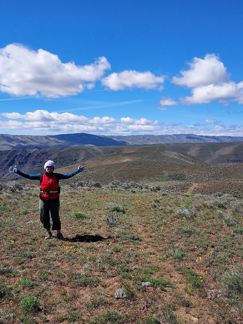
First the fascinating origin of the term: Rattlesnake Dance was a sacred annual ritual performed by the HOPI Nation tribesmen and boys. Every August during a 4-day celebration they caught, washed, buried as many snakes they could, then set them free to fend off the enemies. In 1913 then the 2-term President Roosevelt attended a performance and declared it a sacred event for Hopi Nation not allowing any outsiders unless invited. Above: On this VERY windy day, we didn’t see any snakes. Actually, fighting against the 35-45+ mph crazy winds during the unforgiving fast climb to gain of 1800 vertical feet, it was difficult even to take in the magnificent canyon views. Above: Right out the car, the first mile we climbed 1200 vertical feet up. Steep. Rocky too. Above: Mocha stood sturdy against gusts but was quite puzzled why her ears were flying high.Above: Steve & Mocha leading while I’m earning special credits fighting the wind to snap pictures. The fear was letting the wind blow the phone-camera, gloves and hats out of my grasp. Above: Getting real close to the top. Passed by a group of 3 hikers and one solo with a dog. Above: Standing at the saddle at 2600 ft. altitude. The Yakima River Canyon’s magnificent rolling hills surround us now 360 degrees.Above: Made it to the summit, now standing at 2737 ft. level. Above: Wind persists. But we continue on a unplanned trail to Hill 2658 (unnamed high point at 2658 ft.) so marked on the map.The trail in the background leads back to the ridge summit.Above: A brief break out of the winds, time for a quick lunch. Above: View north to town of Ellensburg and the distant snowy Stuart Range mountains and wind turbine ‘farm’.Above: Harvested this bouquet of Balsamroot flowers to make up for the most invigorating adventure of 4 hours. Will be rocking and swaying with the imaginary wind force for a few days.
NOTE: THANKS FOR SHARING. Hope you’ll try reading a few of my 24+eBooks/Paperbacks on Amazon Kindle.com HAPPY TRAILS.
Above: Can’t wait till the snowshoe gear is all on! Chair lift is done with the season. Hills are all for free spirits like us. There is 800-vertical feet of snow to climb. Some climb and ski down, some cross-country ski both ways. We are on snowshoes and Mocha is sharpening her claws. Above: Start up still requires adjustments of gators and snaps have to be finetuned and poles should feel flexible in case you fall. Above: Last pitch, it’s now 60deg. as snowshoes are starting to slide. I got my share of a super-duper fall, and masterfully landed straight up on both boots! So proud!Above: At the top of Thunderbird Run, chatting with a like-minded outdoorsman, Richard who referred to himself as ‘yo-yo’ cross country skier. He does this up/down three times in a day.Above: Our trio at top. Richard whizzed down already.Mountains left to right Snoqualmie, Guye, Red & Kendall, climbed them all.Above: Perfect lunch spot. Backdrop, on left, Denny Peak (5519 ft.), Snoqualmie Mountain (6278 ft.) and Guye Peak (5172 ft. cone) in front.Above: Too heavy and furry to glissade but will do multiple rollovers.Mocha was in snow heaven.Above: Heading down took more oomph than up.Above: Almost down. Still only 2 skiers in the high levels, but plenty kids, dogs loitering near the parking lot.Above: Despite the high cost of a day lift ticket ($123) during the season this pub gets chuck-a-block full.
NOTE:Still planning the adventure hike to Rattlesnake Dance Ridge. Stay Tuned. Thank You All Followers.
Above: A hiker is pointing at the steep trail that we plan to follow up to a peak @ 3200.ft. Only 40-mls away (Union Gap) there is the phenomenon of Rattlesnake Ridge, also a part of the same Yakima Canyon, that was discovered by geologists in 2017 as a dangerously fast-moving down slope towards the pit. Then the speed of sliding was over 2-inches per week, now as UW geologists refer to it as ‘a constipated’ slide! Having heard that, our planned trek starting from the other side of the canyon, will be safe, only via a ruthless steep angle in the first three miles to reach a phenomenal 360-deg. views. Then kind of languishing hike on the spine. Followed by a very steep climb down.
Pre-warned for predicted high winds, temps. are expected to start from upper 20’s and settle in high 50’s. Follow to share step-by-step. Note: My new book: Meet Me in Bisbee, all of 25 chaptersare waiting in line to be edited to become an Amazon Books Paperback. Teaser-but-not a spoiler: Tonia Torres, the 55+ librarian (heroine) finds her eternal ‘man’ who is no longer a cognitive illusion in her head!
Above: Alaska cruise season’s first ship sails in @ 8.00am. Seattle’s Pier 66 is buzzing with crowds who are lining up to embark while another group, eco and fish life protesters dressed in fish or eco costumes will chant. Above: A little over 20 miles away in Issaquah, a short hike on a rain/shine on popular High Point Trail the landscape is misting, lush green and snow free. Above: About three or so years ago, under heavy storms, this massive cottonwood branch broke from high up and stabbed itself into this very unusual display. It has also become a mother tree to new growth, as in here to many sword ferns.Above: A precious sunny break shines on the Cedar Grove. Groupings of cedar trees within the forest are a natural occurrence.Above: Snow finally is gone so the Trilliums can poke their heads up.Below: Aftermath of storms. The Forest Department field workers have started clearing trails.Above: This cut is beyond recognition but continues a synergetic existence. Co-mingling within the nature. The wood inside this old fir stump has almost completely rotted out. Above: Nose to the ground. Mocha immersed in the scents of wildlife. Bears are not out yet, but the scents from last season are still plenty stimulating. Above: The solace, with the gurgling creek by the side is hard to leave and return to town. Until next hike, next week, So Long. Happy Trails.
UPDATE on my up-and-coming new book: ‘MEET ME in BISBEE’ s plot line has reached and now passed the climax. The crescendo will be a scene where my heroine, Tonia Torres, is coming to terms with her romantic relationship with the elusive man of her dreams. Just saying!
Annual migration from Casa Grande, AZ to Seattle, WA
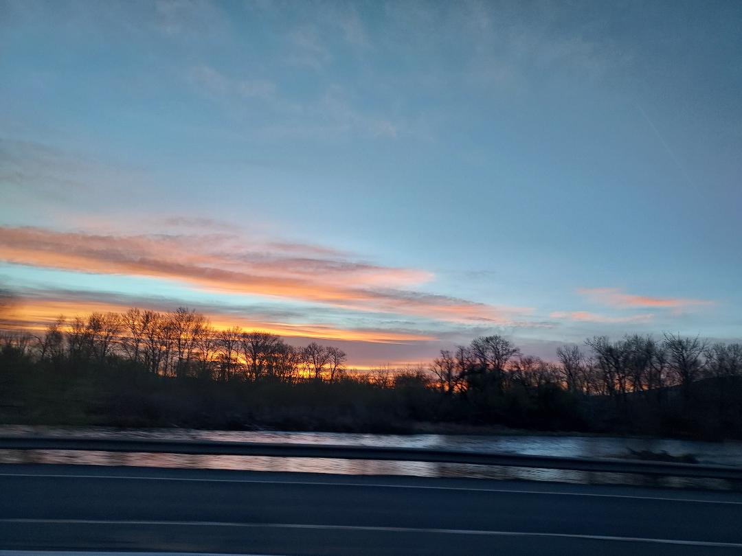
Above: “On the road again”, lyrics made famous by Willie Nelson. (Yes, he is still alive.) Two hundred miles later, glimpse of the impending sunrise with ominous brewing storm clouds in the distance on Highway #93 near Kingman AZ. Below: LEO the cat friend of Mocha, waiting..But it’ll be a long wait till next October. Breaking upis hard to do, number#1 hit of the 60’s by Neil Sedaka.Do not worry, Leo has a real home next block. He’ll be fine. Below: Crossing the Nevada desert en route to Utah border with the storm getting closer and closer. Real nasty rain, hail, graupel, and snow squalls greet and stay on top of us for 450+ miles.Below: Utah’s majestic canyons appear. Severe weather warnings cancel our planned hike to ‘Elephant’s Arch’ near St. George, UT. Forfeit our non-refundable hotel room in Cedar City UT, we soldier on. Below: 28-degree night, a shuteye and dinner break, approaching Idaho border @sunset.We finally leave the storm behind. Only 700 miles left to Seattle, driving through the night. Not much traffic and Idaho speed limit is 80mph, so we zip along.
NOTE:Fortuitously, incident-free safe journey, over-fed with in-car snacks, sleep deprived but the final leg on I#90 leads us back through Washington State. A sunny afternoon glowing in 67-degrees, we pull into downtown Seattle. Rest, sleep and repeat hikes, in Cascades, Olympics…or snowshoe trails with the lingering snow fall. NOTE: All in all, with the exception of a vicious tick-bite, a perfect trip. Now, while on the mend treating weird pathogens with antibiotics, I rely on your comments and support more than ever. PEACE.
Above: April 1, fool’s day is around the corner. And there is stirring life under the rocks, and colour extravaganza popping up above the ground. Above: Magenta Cactus flower. A flower no one will dare to pick!Above: Triplet Saguaros – known by locals as ‘Three Amigos’They’ve seen many Springs and will see many more.Above: Ocotillos at the verge of budding their own red flowers. Give it two full sunny days.Below: Prickly Pear cactus competes with its own deep ‘mauve’ purple production. Below: A handpicked bouquet of potpourri desert spring flowers. They are going home with me!
NOTE: So privileged to see the changing seasons, moods of the nature to affect human’s moods and lives…Stay tuned for the next hike up..wheather permitting back to the Superstitions…a mysterious grotto called: Robbers’ Roost! CIAO!